By Dr Kerry Beggs
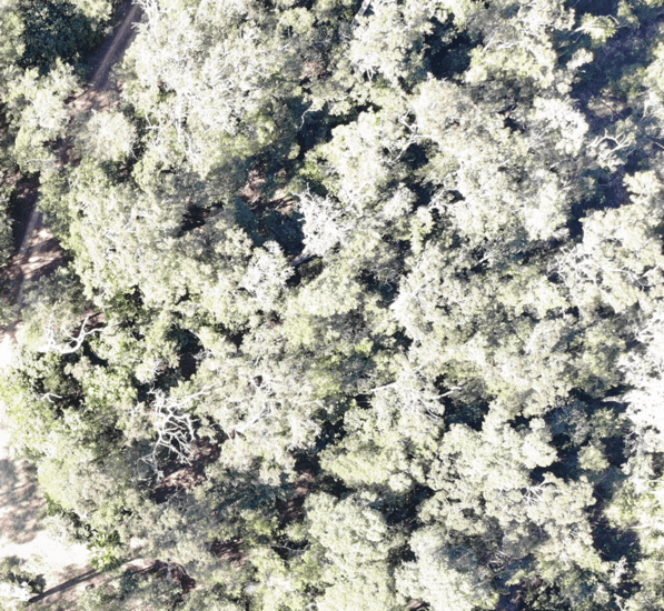
Image: Rainforest north of Townsville – photo taken using my Mavic Air flying at approximately 60m AGL. Understory plants could be seen clearly.
An area I do a lot of work in is weed management – a field I can see huge potential for the use of drones. There are several sites I work on in North Queensland with highly invasive species, such as siam weed (Chromolaena odorata) and lantana (Lantana camara). At present, most of the mapping of these species is done from ground crews as they spray the plants with herbicide, with some aerial mapping done by helicopter. The management is a combination of manual removal, mechanical, chemical (herbicide – from the ground and by helicopter) and planned burns. I can see a big future for the use of drones in weed management!
For example, during a trial in rainforest areas south of Cairns infected with a highly invasive weed, Miconia calvescens, scientists compared images captured by purpose-built drones with observations from scientists mapping the weed by helicopter. The drones were found to perform better than expected, with more Miconia plants spotted than by observers in helicopters. An added bonus is that drones provide a safer alternative than traditional aerial surveys.
Another excellent example that I can see has applications for weed management, comes from the field of precision agriculture. An agricultural student from the University of Queensland developed and tested a drone that could drop beneficial bugs (Californicus mites) onto crops infected with harmful two spotted mites. The beneficial mite eats the pest mite, hence improving the quality of the crop. Manually distributing the beneficial mite at the ground level is very difficult for farmer,s so the ability to spread it from the air saved them time and money.
I would love to use a similar approach to release biological control agents, such as the lantana bugmite, on sites I am currently working on that have poor and/or unsafe ground access.
I have started some of my own very small-scale trials for weed mapping to answer basic questions like – how low do I need to fly to be able to identify particular species? Can all weed species I am interested in be discerned from the air? Can a drone be used in all habitats? A flight earlier this week proved to me that shrubby or ground-level weeds (such as lantana) in the understory of one of my rainforest sites could not be seen. So while drones worked well for spotting Miconia in rainforest, they might not be all that useful on the rainforest sites where I work.
It is a steep learning curve, but I am enjoying the challenge. I hope to grow my skills in this area and one day be at the forefront for using drones for weed management, and especially as a tool for the release of biological control agents. Exciting times ahead for using drone technology in weed management!
She Maps is Australia’s leading expert in drone and geospatial education.
She Maps assist schools with the purchasing of drones, school-industry created drone and geospatial teaching resources and highly supportive teacher professional development.
Ready to buy drones for your school? We are an authorised DJI reseller in Australia

Subscribe by email and never miss a blog post or announcement.
She Maps aims to bring much needed diversity and support to STEM. We do this by providing drone and geospatial programs to teachers and schools across the globe.
At She Maps we acknowledge the Traditional Custodians of Country throughout Australia and their connections to land, sea, and community. We pay our respect to their Elders past and present and extend that respect to all Aboriginal and Torres Strait Islander peoples today.
Aboriginal and Torres Strait Islander peoples are advised that this site may contain names, voices, or images of people who have passed away.
Learn the 6 Steps to Launching a Successful Drone and Geospatial Program at your School
Take our resources for a spin and join the thousands of teachers who love our ready-to-teach classroom materials. Try one of our complete units of work for free.