By Dr Kerry Beggs
This week I am sharing the story of my first proper drone ‘mission’ since obtaining my Remote Pilot Licence and buying a Mavic Air, earlier this year. I have been flying drones long at all – and the first models I ever flew were the Parrot Mambos we use in She Maps sessions.
After lots of practice flying the Mavic Air around my own block, in a rural area outside Townsville, I was up for a real challenge. A teacher friend if I could use my drone to help her out with a maths activity she wanted to do with her students.
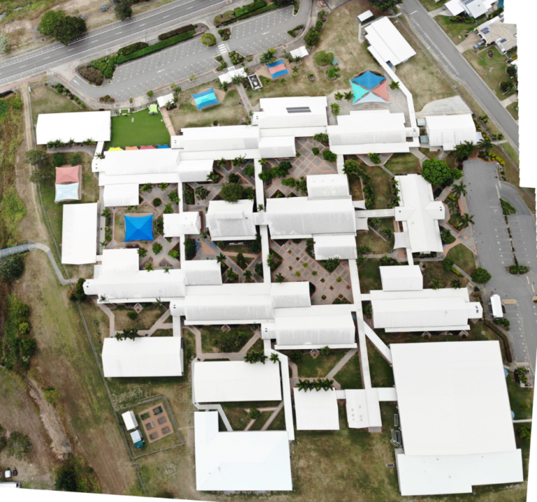
She was seeking a single aerial photograph of her primary school in suburban Townsville, from which the students could make measurements of features such as buildings or footpaths (i.e. with rulers), then also measure the same features on the ground, to work out scale.
I was very keen to help out, but as I know from my licence training – there were lots of CASA rules I’d have to follow.
Firstly, I checked the location of the school (using the ‘Can I Fly There?’ App) – fortunately it was more than 5.5km away from the nearest controlled aerodrome (Townsville airport), but was within 5.5km of a helicopter landing site, so I’d have to keep watch and land if I saw any helicopters nearby.
Secondly, I wouldn’t be able fly over or within 30m or any people, so we planned for a Saturday when the school would be locked up and no-one else would be around, other than me (pilot) and my friend (acting as a spotter). My drone has audio warnings to let me know I’m approach the maximum flying height of 120m, and I knew I’d have to fly only within line of sight – so those rules were covered too. Unless something out of the ordinary happened on the day to create an emergency situation at the school, I was good to go!
Saturday came around and it was a little windy on the day, but a quick test flight revealed it was OK and the drone was flying fine. I flew up to 118m (the highest I’d ever flown – my hands were shaking a little on the controller!), and I started taking photos.
We couldn’t quite fit the whole school in the frame of view at that altitude, so I flew in a rough grid pattern until I had several photos of the whole school. Mission completed, with no crashes or other issues, I was feeling quite pleased with myself!
Back home, I used a ‘photo stitch’ feature in Adobe Photoshop to join all the photos together, and voila! I had the single image. My teacher friend was very happy with the end result, and tells me the students had lots of fun using it to work out scale (and hearing about how the image was obtained!).
Maybe next time the students might be able to be the pilots and create their own aerial imagery of the school!
She Maps is Australia’s leading expert in drone and geospatial education.
She Maps assist schools with the purchasing of drones, school-industry created drone and geospatial teaching resources and highly supportive teacher professional development.
Ready to buy drones for your school? We are an authorised DJI reseller in Australia

Subscribe by email and never miss a blog post or announcement.
She Maps aims to bring much needed diversity and support to STEM. We do this by providing drone and geospatial programs to teachers and schools across the globe.
At She Maps we acknowledge the Traditional Custodians of Country throughout Australia and their connections to land, sea, and community. We pay our respect to their Elders past and present and extend that respect to all Aboriginal and Torres Strait Islander peoples today.
Aboriginal and Torres Strait Islander peoples are advised that this site may contain names, voices, or images of people who have passed away.
Learn the 6 Steps to Launching a Successful Drone and Geospatial Program at your School
Take our resources for a spin and join the thousands of teachers who love our ready-to-teach classroom materials. Try one of our complete units of work for free.