Our school is NOT Cool! How to become change makers with maps.
Katie Vidal
20 Sep 2022
Planes, drones and maps
St Peters Primary, Epping planned an inquiry unit on flight. It would start with balsa wood planes and looking at the invention of first flights and would finish with surface audits of their school grounds and using drone technology with purpose.
Watch this
Watch Melissa Gatt, Rachael Lorkin and Laura Mercuri explain how they created this Inquiry unit on flight as they were guided by the Year 5-6 achievement standards in the science curriculum and the national mapping competition “How Cool is Your School?”
Flight Inquiry Unit
This inquiry unit began as an investigation into flight using balsa wood planes. By designing and testing their projects students studied how flight happens. They looked into flight innovation, designing their planes and testing their capabilities of speed, payload and other innovation challenges.
It created a strong hands-on environment for students to problem solve and understand how flight works. The teaching staff at St Peters did not want to stop the inquiry unit there, they wanted to take it further.
What was next for St Peters, Epping inquiry unit of flight?
Drones and GIS in the classroom
Drones and geospatial information systems were the solution (GIS). There are numerous types of flight advances in the drone sector, and they are contemporary technology employed in various businesses.
But St Peters did not want to just explore different drone technology and the ways that drones moved. Using the problem-based approach with the mapping competition How Cool is Your School? as part of their inquiry unit, they were able to look at drone technology and its use in data collection.
This then led to an investigation into the school playground and the amount of green shade that it provides.
The resources included in the competition were the Winner – 2022 AGTA Awards for Primary Resource.
How Cool is Your School
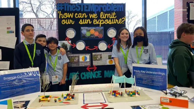
How Cool is Your School is a nationwide Australian mapping competition that challenges students to look at the amount of shade within their school boundaries.
Trees not only shade us from the sun’s direct rays but also aid in keeping us cool. They resemble the air conditioners found in nature. Trees use a technique known as “transpiration cooling.” Water enters the plant from the soil and finally departs through the leaves and branches. Similar to how humans perspire, this aids in cooling the plant. As an added benefit for humans, the water that leaves the plant as gas or water vapour also contributes to the cooling of the air surrounding it by up to 5oC!
So how much shade did St Peters have in their school grounds?
Map Inquiry
Students went through a series of investigations, including how to:
Calculate the percentage of shade and create a map that meets cartographic (mapping) conventions. The maps were entered into the She Maps Mapping Competition;
Understand the basics of image interpretation and creating maps;
Use freely available online satellite data and basic image interpretation to create a map of the school;
Determine the percentage of green shade available on the school grounds compared to other features; and
Teach students how to use satellite data to extract information relating to an environmental challenge.
“Oh my gosh Miss, this school is not safe for us!”
Inquiry Process in Action
1. Global warming and its effects on the environment
Students looked at what global warming was and how it was affecting the world, Australia and humankind. The negative effects of these environmental events were highlighted by the students looking at sun exposure and the effect it has on human health eg melanoma
2. The outdoor school environment
Students took images of their outdoor learning spaces and their play areas to retain for their own research
3. Introduction to GIS
Students are introduced to a geographic information system (GIS), Geonadir. This is the world’s first central repository for storing and managing Findable, Accessible, Interoperable, and Reusable (FAIR) drone data. Schools choose satellite or drone imagery to map the amount of green shade on their school grounds.
4. Maths in mapping
Once the shade had been identified and mapped using the tools in Geonadir. The students could then calculate building to playground percentages, which then led to calculating the percentage of shade in their playgrounds.
5. The light bulb moment
The students took the knowledge they learnt throughout their inquiry unit and began to understand what kind of outdoor environment they were learning and playing in. They began to understand that not only was there minimal shade (less than 10%) in their playground, but also the times of the day that they were outdoors also affected the amount of shade that they could access. The next step was what could they do with this knowledge.
6. Becoming change-makers
How do you encourage students to become change-makers? Firstly, students need to understand and develop empathy for others and they need to see examples of other change-makers. If they can see it, they can be it! She Maps and the How Cool is Your School competition allowed students to become “shade advocates”. They could identify the percentage of shade in their playground and how that was affecting students as they learnt and played. Then, by utilising the genre that the senior teachers were exploring- Persuasive writing – students planned and wrote letters to their principal, not only expressing their concern but also providing evidence.
They were able to identify a specific area in the school grounds that needed shade to improve the playing and learning environment for their peers. They had become change-makers in their community and had started the planning of future shade areas for the younger students.
Holistic Approach to STEM
Using How Cool is Your School as a holistic approach to STEM allowed students to take on a problem in their school environment while learning and applying skills from across the four learning areas. This included using the inquiry approach to learning, design process, maths implementation and the use of digital technologies (drones and GIS) to solve real-world problems in their own school environment.
St Peters, Epping were able to use an inquiry process to not only learn about flight, but also develop skills for the future that are an essential part of future careers.
STEM reimagined
About She Maps.
She Maps is Australia’s leading expert in drone and geospatial education.
She Maps assist schools with the purchasing of drones, school-industry created drone and geospatial teaching resources and highly supportive teacher professional development.
FREE eBook – How to start a drone program at your school – Teachers Guide – Download Now
Learning Solutions Guide – Programs, Products and Pricing Guide – Read now
Ready to buy drones for your school? Browse our convenient classroom kits!
You’re in Safe Hands!
She Maps is a CASA approved commercial operator to fly microdrones indoors with students and teachers. CASA holds commercial operators, to a higher standard than recreational users and educators. This means that She Maps has been assessed by CASA as having rigorous training and risk mitigation procedures in place.
Want some help?
Schedule a call with one of our team members to get some personalised recommendations.
Take our resources for a spin and join the thousands of teachers who love our ready-to-teach classroom materials. Try one of our complete units of work for free.