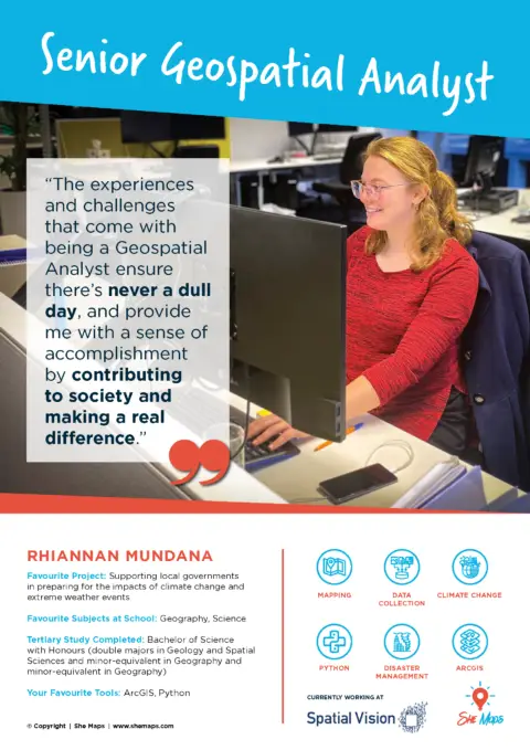
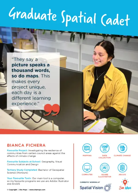
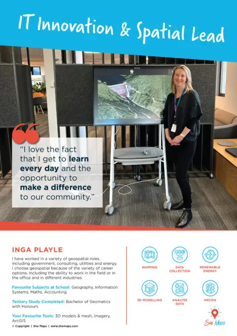
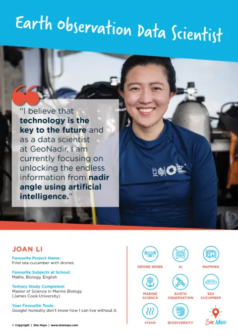
The She Maps Membership

A portal of professional learning and teaching resources, helping you use programmable drones in the classroom.

Students learning with drones, maps, and tablets in school.

Professional development and teaching resources in one place​

she maps membership (2)

Recognised professional development

Self-paced, on-demand materials included in your She Maps Membership
resource single cover cde

Classroom Drone Essentials

Yrs 5 - 10

Classroom Drone Essentials is both professional development and classroom resource. It teaches you about the different types of drones and their application in various industries, as well as provides a step-by-step guide on how to teach manual drone flying and coding drones using block coding.

resource single cover cme

Classroom Mapping Essentials

F - 10

Classroom Mapping Essentials is designed to equip teachers with the skills to integrate mapping and geospatial applications in their lesson plans with confidence. Explaining historical and modern mapping conventions, along with foundational geospatial concepts, this is PD no geography teacher should miss.

drone mapping

Advanced Drone Mapping

Yrs 10 - 12

Drone Mapping is designed for teachers planning on taking their students outdoors to undertake drone mapping activities with larger sub 2kg drones.
This course will teach you how to use your drone to capture, manage, and perform basic analyses of drone image data.

Ready-to-use classroom materials

The resources included in our membership help teachers utilise programmable drones and geospatial concepts to teach across a variety of STEM & HASS subjects
Teaching with drone classroom resource - Healthcare in the Himalayas

Healthcare in the Himalayas

Yrs 5 - 9

Mapped to: HASS, Geography, Digital Technologies, Design and Technologies, Mathematics

In this unit of work, students will simulate the transport of critical medical supplies to remote villages in the mountains, using drones.

Drones in Agriculture: Teacher Resource Pack Cover

Drones in Agriculture

Yrs 5-6, 7-8 & 9-10

Mapped to: Science, Digital Technologies, Design and Technologies, Mathematics

In this unit, students will learn about the use of drones in agriculture, and design, plant and monitor a mobile vegetable garden using various learning processes.

Drones to the Rescue Floods Years 7 8

Drones to the Rescue - Flooding

Yrs 7-8

Mapped to: Geography, Digital Technologies, Design and Technologies

This unit investigates the causes and impacts of natural disasters and how can drones be used to minimise the risk of natural hazards.

Drones aid bushfire response and rescue operations.

Drones to the Rescue - Bushfires

Yrs 5-6 & 7-8

Mapped to: HASS, Geography, Science, Digital Technologies, Design and Technologies

How can drones and Geographic Information Systems be used to support research and recovery after a bushfire event?

resources unit of work code fly deliver 900x900

Code. Fly. Deliver.

Yrs 5-6 & 7-10

Mapped to: HASS, Economics & Business, Geography, Digital Technologies, Design and Technologies, Mathematics

Drones are increasingly used for product deliveries. Let your students create their own drone delivery solution that solves a community need.

Cover of 'Drones in Forestry' booklet.

Drones in Forestry

Yrs 5-6 & 9-10

Mapped to: HASS, Geography, Digital Technologies, Design and Technologies

How can drones and Geographic Information Systems assist foresters in managing the forest environments that provide sustainable and renewable resources for society?

Book cover: Map My School, grades 1-12.

Map My School (UoW)

Yrs F-8

Mapped to: HASS, Geography, Digital Technologies, Design and Technologies, Mathematics, Science

Map My School teaches students how to create maps and calculate the size of surface areas.

*Does not require the use of drones.

Illustrated map of neighbourhood with water and stadium.

Map My Neighbourhood

Yr 7

Mapped to: HASS, Geography, Digital Technologies, Mathematics

In this unit, students explore their neighbourhood, create a map to plot its liveability, and use data to propose improvements.

*Does not require the use of drones.

Industry resources

Providing a link to the geospatial and drone industry
industry resources (1000 x 800 px)

We believe teaching with drones should be easy and stress-free.

That’s why we made our membership an affordable, zero-fluff training platform to enable teachers of all skill levels to succeed with drones.

Fly solo or sign up your whole team

FOR 1 TEACHER

$ 22
92
per user per month billed annually
  • $275 total cost for 12 months
50% off renewals

FOR 5 TEACHERS

$ 8
25
per user per month billed annually
  • $495 total cost for 12 months

FOR 10 TEACHERS

$ 7
45
per user per month billed annually
  • $895 total cost for 12 months

FOR 20 TEACHERS

$ 6
65
per user per month billed annually
  • $1595 total cost for 12 months

Why schools love our teaching resources

Drone training

Utilise modern teaching tools and set your school apart from others

Digital technology

Equip students with 21-st century skills and give them a competitive advantage

Real-world examples

Solve industry-led challenges and explore best practices with your students

Inclusive

Spark curiosity and confidence among students of all backgrounds & skill levels

Try before you buy

Membership with a greater purpose

By becoming a member, you will be helping us to achieve the following...
website icons goals purpose

Eliminate unconscious bias in the classroom

Our programs and resources show diversity in how STEM is perceived and who does it. We need to encourage more girls to pursue a career in STEM by challenging the unconscious bias that exists. Your teaching can help us achieve that.

Simply download and start eliminating unconscious bias in your classroom.

Download the ebook Free

Impact countries

Create impact

As a certified Social Enterprise we provide under-served communities with STEM opportunities, commiting 50% of our profits to our Impact Program projects.

STEM career posters

Did you know that two thirds of children aged nine to eleven draw a man when asked to draw a scientist? Today, women are vastly underrepresented in science and technology industries.

She Maps have created a suite of free posters to celebrate some wonderful role models and the important work they do.

We're here to help...let's talk!

Schedule a meeting with She Maps at a time that is convenient for you.

What's new!

For the latest tips, tricks, and news, check out our most recent articles.

Try before you buy

Take our resources for a spin and join the thousands of teachers who love our ready-to-teach classroom materials. Try one of our complete units of work for free.

drones in forestry yr 5 6
drones in forestry yr 9 10