Applications of GIS in Transportation – STEM Career Series
She Maps Team
25 Feb 2025
In this STEM Career Series, we will talk about the role of GIS Careers in Transport. Read on to find out what career opportunities exist today!
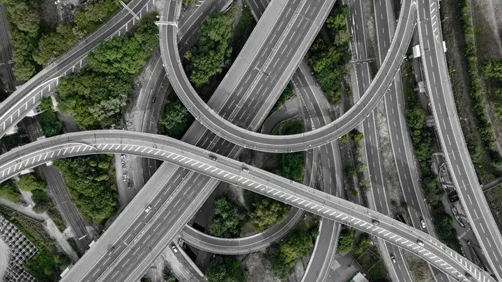
On any given day, nearly 1.5 million people are present on Melbourne’s busy roads. There is almost always some form of construction work going on, with several pedestrians crossing roadways throughout the day. On top of that, there is the constant re-routing of paths, the possibility of accidents, unexpected harsh weather… the list goes on and on.
The automobile industry is always striving to make our everyday travel experience on the roads much safer and more efficient. GPS is one such technology which has revolutionized the way we travel. Many auto manufacturers have also begun exploring the exciting arena of driverless cars which could soon become an everyday reality on the roads. GIS is heavily relied upon in the automobile industry to aid in the precise navigation of areas with minimal human interaction. In this article, let’s look at:
GPS
Driverless Cars
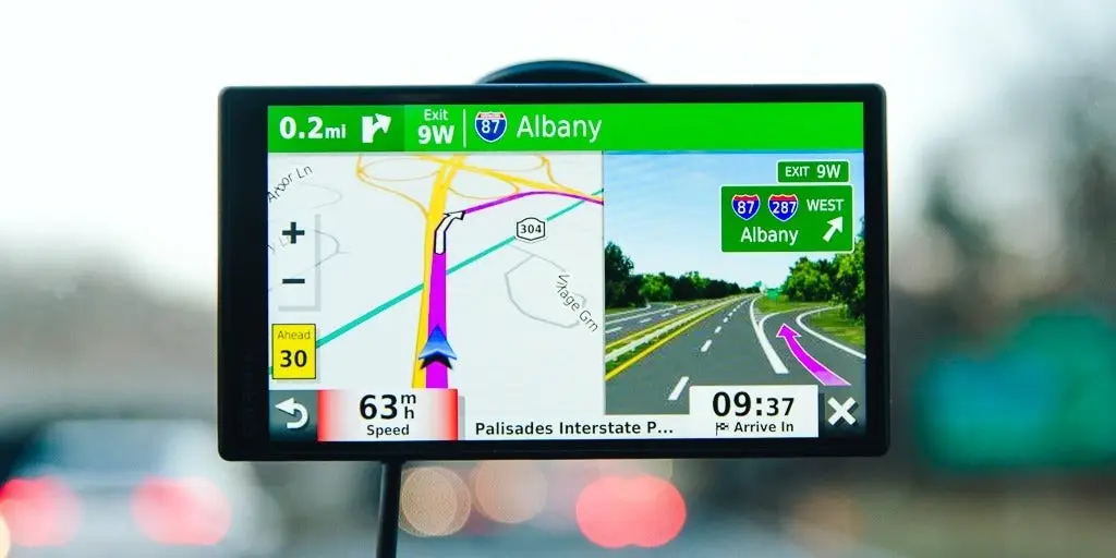
Global Positioning System (GPS)
GPS is one of the most common and inexpensive technologies used for navigation purposes. The GPS system in our handheld devices acts as the receiver, while the GPS satellites orbiting the Earth are the transmitters. These satellites transmit low power radio waves through space to the receiver, allowing users to pinpoint any location in the world. Virtual mapping has benefited the most from GPS technology as we are now able to gather and consolidate spatial information about almost any location on Earth using satellites.
However, all this raw data obtained from GPS systems is meaningless until it is interpreted and analyzed accurately. GIS technology transforms this data into useful information and facilitates the analysis of patterns and the prediction of future outcomes. Large GIS databases can layer maps obtained from different sources on top of one another to create a more informative map. Essentially, the technology helps unlock the true potential of data gathered by GPS systems.
The integration of drones with GIS technology is revolutionizing accident analysis and compensation claims in the transport sector. Drones equipped with high-resolution cameras and sensors can rapidly capture detailed aerial imagery and 3D models of accident scenes, providing precise data on vehicle positions, road conditions, and environmental factors. This information, when combined with GIS mapping, allows for accurate reconstruction of incidents, helping insurance companies and legal professionals assess claims efficiently and fairly. By streamlining the data collection process and reducing reliance on manual inspections, drones not only save time and costs but also contribute to more informed decision-making in resolving car compensation claims.
Driverless Cars using GIS
As humans, we can perceive our surroundings at a given time and anticipate movements. For instance, if a police officer holds a STOP sign at a junction, our brains expect all the vehicles moving in that direction to obey the order and come to halt. Or if the light for pedestrians’ flashes green, we anticipate that someone might cross the road.
But how can so-called driverless cars, now manufactured by a lot of companies, achieve this level of intellect? Robust maps are at the core of successful navigation systems. But manufacturers must be able to equip these maps with real time information to ensure optimal efficiency and safety for the passengers.
To understand this, let’s jump into the brain of the driverless car. A technology called LiDAR is utilized to estimate distances from point A to B. A LiDAR system sends a pulse of light from point A to point B. It then measures the time taken for the light to return to the sensor. Using fundamental principles, the distance to point B can be calculated using the time taken for the pulse to reach point B and the speed of light.
Cameras are another essential component that allow driverless vehicles to recognize all the different features of a road such as pedestrian or brake lights through feeding them information about signs, colours and textures.
Using these components (along with other sensors), the environment of the car is constantly scanned with each movement. Based on the input received from the cameras and sensors, SLAM (Simultaneous Localisation and Mapping) technology allows these cars to map their surroundings in real time, creating a 3D map. Moreover, it has the flexibility to alter the response of the car based on these inputs, hence enabling it to mimic human instincts. Machine learning algorithms allow inputs from sensors to be converted into commands so that the car understands and orients itself based on the information it receives about its surroundings.
Top GIS Careers in Transport
The automobile industry is a fast-growing industry, and it offers a wide range of career opportunities. Some of the GIS career opportunities in the automobile industry are listed below:
GIS Analyst: This role involves managing geospatial displays and topology tools using scripting languages. GIS practices and metadata standards are to be practiced throughout the role.
Software Engineer: Building new and creative application experiences to enhance the core functionality of map-based driving is one of the key roles. Using programming and software components, software engineers fuse data from the map after localization with perception. They are also responsible for creating code and designs that abide by automotive quality and safety standards. Check out an exciting opportunity here!
Co-op Data Engineer: Responsibilities would generally include creating and maintaining high-definition Geo-spatial data to support self-driving technology. Communicating with other teams regarding map and performance updates is also a key aspect of the role. Internal tools must be utilized to analyze internally generated data for quality control purposes. Check out an opportunity here!
Technician: Utilizing a set of web-based tools, technicians complete a variety of mapping tasks. These may include digitizing road features such as signs and lanes, attributing features with appropriate metadata, associating features with one another to create entity relationships, and defining relationships between map objects. Highly accurate vector maps are to be generated using internal tools.
If you enjoyed this article, then you might want to read more in our STEM Career Series:
She Maps is Australia’s leading expert in drone and geospatial education.
She Maps assist schools with the purchasing of drones, school-industry created drone and geospatial teaching resources and highly supportive teacher professional development.
FREE eBook – How to start a drone program at your school – Teachers Guide – Download Now
Learning Solutions Guide – Programs, Products and Pricing Guide – Read now
Ready to buy drones for your school? Browse our convenient classroom kits!
You’re in Safe Hands!
She Maps is a CASA approved commercial operator to fly microdrones indoors with students and teachers. CASA holds commercial operators, to a higher standard than recreational users and educators. This means that She Maps has been assessed by CASA as having rigorous training and risk mitigation procedures in place.
Want some help?
Schedule a call with one of our team members to get some personalised recommendations.
Take our resources for a spin and join the thousands of teachers who love our ready-to-teach classroom materials. Try one of our complete units of work for free.