Partnering with purpose to create the next generation of geospatial professionals
Paul Mead
29 Apr 2025
Partnering for Purpose
To create the next generation of geospatial professionals, it is a team effort. There are many aspects, influences, and experiences that have an impact on students choosing what to do after they leave school.
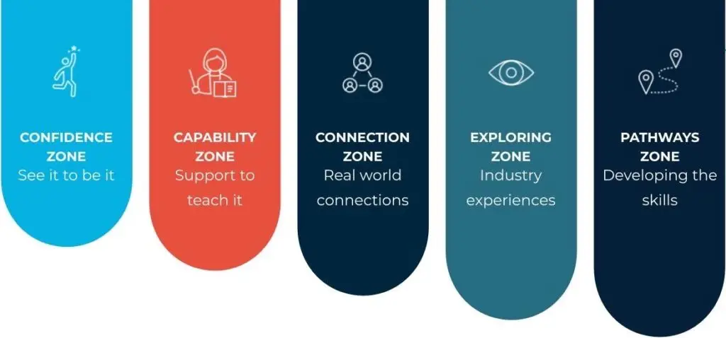
She Maps has created the Partnering for Purpose model to provide a framework for engagement of students from early primary school through to career entry. The model shows five zones that are all interlinked and form the pathway. This pathway is like a buyer’s journey in marketing where awareness, consideration, and decision are key stages.
Each stage in the Partnering for Purpose model has a key focus to deepen the relationship with the student, increasing the likelihood of career entry into the geospatial profession.
The outcome (or purpose) of the model is that we create a sustainable career development pathway for the geospatial sector. She Maps has its roots in the geospatial sector with our co-founder, Dr Karen Joyce, being a remote sensing scientist and drone pilot. This purpose is not one that She Maps owns, it is a collective purpose and responsibility for the sector, where She Maps supports key stages of the model.
To achieve this outcome, then partnerships are key. There are so many individuals and organisations involved in ensuring this model works, that we must all be working together. It starts with schools, teachers, and parents, and continues with industry, industry member organisations, TAFEs, Universities, and Government. Everyone has a role to play in achieving the collective purpose.
A skilled workforce is essential for the sector to be able to keep up with construction demands, and spatial data analysis needs across a range of industries. Workforce shortages have been looming for over a decade at a time when critical infrastructure projects are coming online and spatial data is being used at an increasing rate. Without the workforce then projects will be delayed, costs will blow out, and poor or wrong decisions will be made due to a lack of data analysis.
The Partnering for Purpose model is a structured and coordinated framework that supports engagement with the sector from early primary school to entry into the profession. It is a longitudinal pathway, where funding a program in primary school for instance won’t produce an immediate or short-term impact on career entry statistics. Likewise, funding only a portion of the model will mean that critical stages are neglected and the whole of model engagement is ineffective. To achieve the desired outcome, then the whole of model needs to be considered, developed, and funded.
The Partnering for Purpose model has five key Zones.
Confidence Zone
Children form views early in their primary years about societal, cultural, and gender stereotypes and what they believe they are capable of doing in the world. As they enter into high school and start puberty, then these views and sterotypes are cemented further. By the time students reach Year 10 and are making subject selections, which impact tertiary education choices, their views about what they are and are not good at are almost impossible to change!
By working with students early in their primary years, through to early high school we can expose them to programs and role models that increase their confidence in STEM based subjects and career options.
We help students step forward into the activities through careful design of our educational resources, and use of a range of role models that students can relate to.
If they can see themselves in the role models, then they can dream of being a geospatial professional.
Capability Zone
Our teachers are stretched thin with an increasing workload and many of them are teaching out of field. This means that they might be teaching a geography or digital technologies subject but have not had any technical training through their degree in these subjects. Often, they are learning the material a few weeks ahead of their students. This becomes challenging for teachers who want to create engaging lessons, and stretch their students, if they are just keeping up themselves.
We help increase the capability of teachers by providing ready to teach units of work (curriculum aligned lesson plans and student activities), which are engaging and linked to real world applications. We also provide teacher professional development to ensure that teachers are well supported with all their questions.
If teachers are supported to teach it, then they are more likely to teach highly engaging lessons which students will enjoy and want to explore STEM and geospatial skills (and opportunities available in the geospatial sector) further.
Connection Zone
Students (and their parents) want to know ‘how is this relevant to the real world, and will my child get a good job?’
We bring real world connections into every program, activity, and lesson plan we create. We showcase real people doing real work and explain what students are learning in the classroom is used in the workplace. Our units of work have all taken a problem being solved in the real world and ‘miniaturised’ it to be classroom friendly.
If students can see the relevance, and if teachers can see the connections, then the content is more likely to be taught.
These first three zones must be implemented correctly for the industry or sector to ‘earn the right’ to effectively implement the next stages of the model. Trying to implement the Exploring Zone without ‘warming up the audience’ means students and teachers will have low post activity engagement with the activities in this zone.
Exploring Zone
If students feel a connection with the sector or industry, they are more likely to explore what study and employment options exist for them post high school.
Industry bodies and tertiary education providers become more active in this space with activities such as:
Come and try days
Work experience
Open days
Career fairs
Mentoring programs
These activities are essential to giving students more information, context, and capturing their interest, and their parents/caregivers in the next stage of their decision making about their future work choices.
If students have not been exposed to the sector or industry before this point, then they are less likely to be an active participant in these activities. The previous three zones are designed to broaden to pool of students who have been exposed to the sector or industry, increasing the likelihood of student engagement in the Exploring Zone.
Pathways Zone
If Industry bodies and tertiary education providers have effectively engaged students in the Exploring Zone, then students will be receptive to information about pathway options. Students who have had continuing positive engagements and build a positive sentiment across all of the Partnering for Purpose Zones, are more likely to choose a career pathway in this sector or industry.
In this Zone, industry bodies and tertiary education providers need to provide simple to understand information about career pathways, study options, study costs, and expected pay rates.
It is at the end of this Pathway Zone that a new industry professional is ‘created’.
The Partnering for Purpose model is not owned by anyone. It is a framework for collaboration. No one organisation or activity is solely responsible for ‘producing graduates’, nor can any one Zone be judged as being more important than another. If Zones are neglected in terms of a lack of programs or poor linkages to adjacent Zones, then an impact will be felt at the end of the model with less industry professionals exiting the Pathways Zone.
Implementation
This model is not unique to the geospatial industry. It is a simple framework for engaging students early, supporting teachers, and exposing students, teachers, and parents to the industry or sector.
It requires all organisations with an interest in the various zones to collaborate and partner. Working in isolation in your ‘chosen zone’ creates silos where information is not shared and the information required to create linkages between zones does not occur. Reliance should not be placed on one activity in each Zone. Multiple touch points and experiences should be offered to ‘see what sticks’ with students and teachers. Not every activity or program is going to resonate with everyone – having choice, options, and different experiences will increase the likelihood of attracting a broader cohort of students through the zones.
She Maps has been implementing the Partnering for Purpose model for the geospatial industry since 2019. We are always looking for partners to join us to create the next generation of geospatial professionals.
About She Maps.
She Maps is Australia’s leading expert in drone and geospatial education.
She Maps assist schools with the purchasing of drones, school-industry created drone and geospatial teaching resources and highly supportive teacher professional development.
FREE eBook – How to start a drone program at your school – Teachers Guide – Download Now
Learning Solutions Guide – Programs, Products and Pricing Guide – Read now
Ready to buy drones for your school? Browse our convenient classroom kits!
You’re in Safe Hands!
She Maps is a CASA approved commercial operator to fly microdrones indoors with students and teachers. CASA holds commercial operators, to a higher standard than recreational users and educators. This means that She Maps has been assessed by CASA as having rigorous training and risk mitigation procedures in place.
Want some help?
Schedule a call with one of our team members to get some personalised recommendations.
Take our resources for a spin and join the thousands of teachers who love our ready-to-teach classroom materials. Try one of our complete units of work for free.