

Many of us see surveyors working with their tripods by the roadside but have a limited understanding of what it is they do or just how different and exciting their jobs can be. We’re on a mission to showcase surveying! We’re teaming up with a number of young surveyors across the world to bring you their favourite projects and what they love the most about working as a surveyor.
Surveying is the measurement and mapping of our surroundings using mathematics, specialised technology and equipment. Surveyors measure just about anything, from buildings and structures, to the land, the sky or the ocean bed. They even measure polar ice-caps!
Whilst surveyors use maths skills and technology to do their jobs, there is also a strong link to Geography. Surveyors use geographical inquiry skills on a daily basis to observe, question, and plan how to solve problems. They collect, record, and represent information and data from a variety of sources.
Once they have this information, then they make interpretations and conclusions, then communicate these results and findings to a wide variety of audiences.
This series showcasing surveyors, is designed to show students and teachers how the curriculum content can be bought alive in real-world examples.
Janina is a Geodetic Surveyor who works for the Department of Resources within the Queensland Government. She has a Bachelor of Science in Geodetic Engineering and her favourite subjects in high school were Maths, English, and Programming. Her favourite project that she has worked on as a surveyor was assessing land parcels on Mulgumpin (Moreton Island) as part of a native title determination.
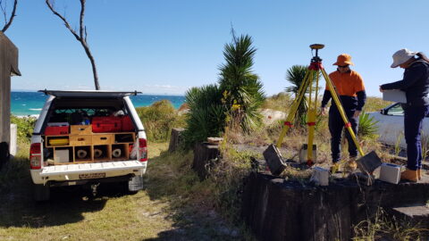
Janina conducting surveys on Mulgumpin.
The Quandamooka People are First Nations custodians of lands and waters within parts of Moreton Bay, and have more than 20,000 years’ association with their Country. The Quandamooka People include three clans of Aboriginal people; the Ngugi people of Mulgumpin (Moreton Island) and the Noonuccal and Gorenpul people of Minjerribah (North Stradbroke Island). Similar to Minjerribah, Mulgumpin boasts a rich and significant cultural history and the Quandamooka People have a strong spiritual connection to the island. Numerous cultural sites have been recorded over the island and include shell and bone scatters, large shell middens and a stone quarry.
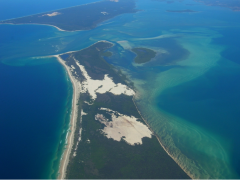
Southern part of Mulgumpin
Native Title is the recognition that Aboriginal and Torres Strait Islander people have rights and interests to land and waters according to their traditional law and customs as set out in Australian Law. It is governed by the Native Title Act 1993. In 2019, the Federal Court recognised the Native Title claim made by the Quandamooka People, acknowledging that Moreton Bay’s islands were always Quandamooka land. Here is a great resource to explain more about Native Title.
As part of the negotiations for the proposed state land actions, Janina’s job was to accurately reinstate and mark out the boundaries for individual land parcels on Mulgumpin which formed part of the tenure package. To do this, Janina used geodetic data, which is the data obtained from GPS or GNSS (Global Navigation Satellite Systems), as well as cadastral surveying. Cadastral surveying is the process of accurately defining property boundaries and understanding the laws of land ownership. This may include the identification of residential or rural boundaries, re-establishing boundaries that have been previously surveyed or creating new boundaries as part of the land subdivision process.
Janina used her skills and knowledge to interpret and advise on the location of the land parcel boundaries on Mulgumpin. Given that parts of the island were largely unsurveyed, she undertook survey work on areas of land that were State-owned to ensure there was an accurate land description registered in the Titles Office. The information and measurements taken during the cadastral surveys were used to produce a survey plan. This survey plan included a reinstatement report, outlining how the reinstatement of land boundaries was carried out, what the considerations were, and what decisions were made, as well as water boundary report, as some of the land parcels were bounded by tidal and non-tidal water.
Survey site on Mulgumpin
The Federal Court made a Native Title consent determination for Mulgumpin (Moreton Island) on 27th November 2019. Their native title determination recognises the Quandamooka People’s rights that include to live and be present on the determination areas, conduct traditional ceremonies, take, use, share and exchange traditional natural resources for traditional practices, conduct burial rites, teach about the physical and spiritual attributes of the area, and maintain places of importance and areas of significance.
Joint management arrangements are being progressed for Mulgumpin’s National Park and Recreation Area between the Quandamooka People and the Queensland Parks and Wildlife Service, building on the successful joint management currently in place on Minjerribah (North Stradbroke Island). This will include additional Quandamooka Rangers and new opportunities for eco-tourism on Mulgumpin. The Quandamooka Native Title also recognises some small parcels of sacred land for exclusive use.
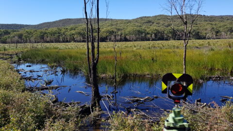
Surveying a water boundary
What Janina likes most about surveying is that no one day is like another, it is a constant adventure! She says that she never stops learning, which keeps her engaged and excited in the work. During the Mulgumpin surveying project, Janina learnt a great deal about historical and cadastral surveying, Native Title, and state land actions. Surveying has been different to what she first expected in that there are so many broad and varied work opportunities.
Inspired by Janina’s story? Download the poster to display in your classroom.