How to become a Data Scientist – Dr Caitlin’s Journey
Katie Vidal
09 Jan 2023
Meet Dr Caitlin Adams
Dr Caitlin Adams works as a Senior Data Scientist at FrontierSI, applying machine learning to remote sensing data to improve the development of spatial data in Australia and internationally.
Caitlin is a deeply creative thinker with a passion for solving the complex problems humanity faces. She is a passionate, hard-working, and considerate person who deeply appreciates learning from and teaching others. After completing a Bachelor of Science (Honours) at the University of Queensland, Caitlin obtained her Ph.D. in Astrophysics at Swinburne University of Technology.
The path to becoming a data scientist
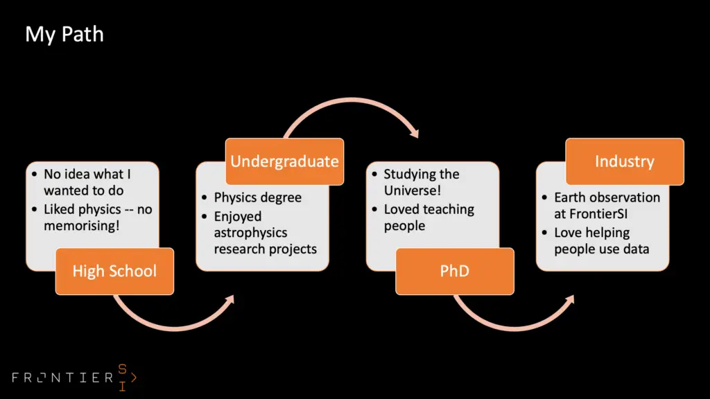
When Caitlin was at school, she had no idea what she wanted to do for a career. She wasn’t a fan of memorising facts and figures and loved Physics because it helped explain how things work in the world around us (plus there was no memorising involved!) Her love of physics led her to study a Bachelor of Science as her undergraduate degree where she majored in Physics. It was during this time that Caitlin discovered how much she loved Astrophysics.
Caitlin concentrated on Astrophysics for her post-graduate studies and completed a Ph.D. Her passion was studying the universe and Caitlin discovered that she loved teaching people what she knew. So armed with her Ph.D in Astrophysics Caitlin headed out into the world of work and landed a position in Earth observation at FrontierSI where instead of looking out at the universe, she focussed inward on Planet Earth. It was at FrontierSI that Caitlin discovered that she loved helping people make sense of the world around them through geospatial data analysis.
Machine learning technologies vs Artificial Intelligence
Data takes a long time to clean up and process so Caitlin and her team accessed machine learning technologies to help them in a very important task – mapping the vegetation of the state of Victoria.
You might have heard of machine learning and think it’s the same as artificial intelligence. Caitlin explains the difference between the two for us.
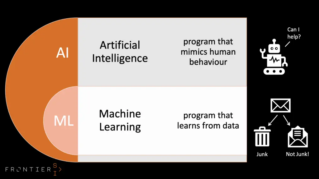
Artificial Intelligence
Artificial intelligence is a program that mimics human behaviour such as a chat-bot. You might not even realise that you’re not talking to a real person when using the chat function on a website.
Machine Learning
Machine learning is different. It doesn’t just mimic, it learns. By training a computer with lots of images a computer can learn to recognise something in an image and tag it to help with classification. Have you ever had to identify all the traffic lights in a series of pictures so you can progress on a website or verify you’re human? This Captcha technology is a form of machine learning and you’re helping train the computer to recognise traffic lights.
The process of recognising vegetation in satellite imagery
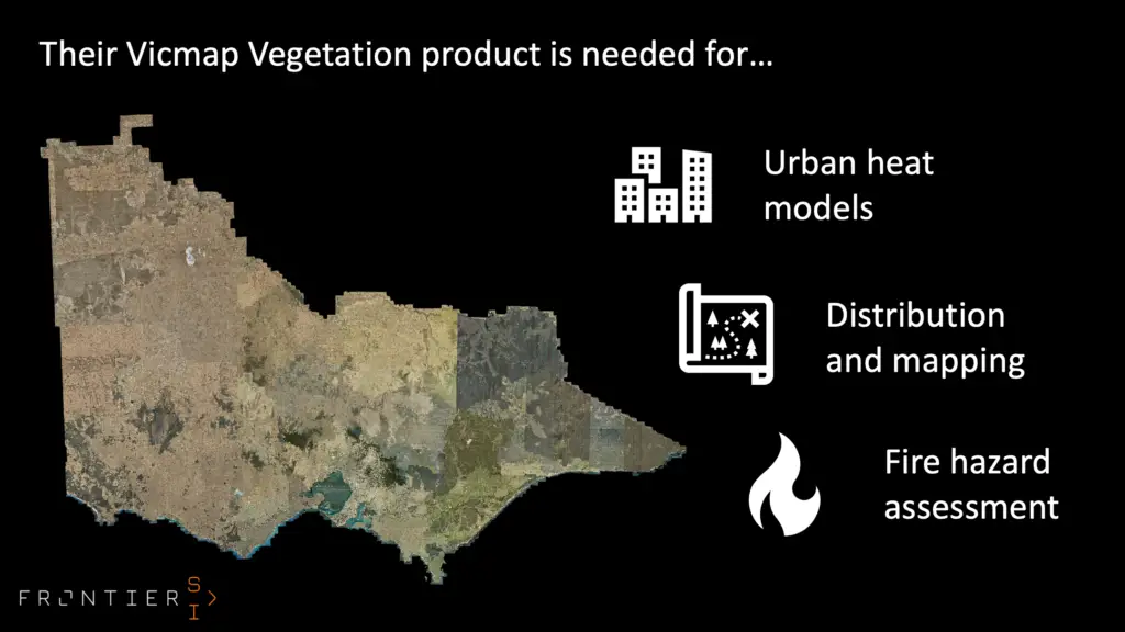
Caitlin and her team trained computers to recognise images of vegetation from satellite imagery as part of the DELWP project to update spatial data for the Vicmap Vegetation product. The data helps town planners and Policy makers understand changes in urban heat models and assess fire hazards. The main problem was that the map hadn’t been updated since 2001!
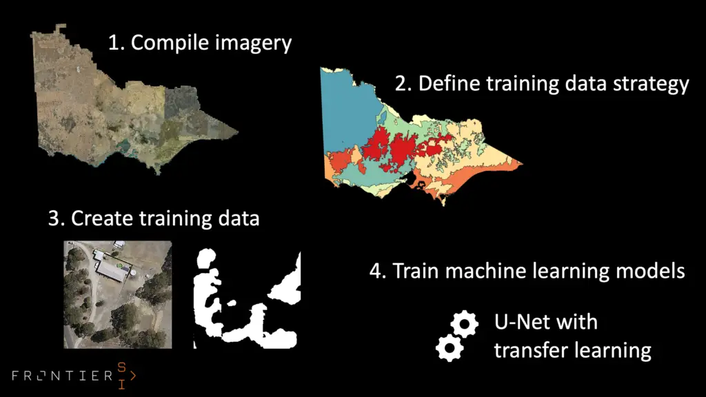
Caitlin and her team compiled imagery and looked for patterns in the data to define what rules were needed to train the computers to recognise clusters of vegetation. They then trained and tested the computer systems until they were sure they had a robust system. They adapted a similar system and taught it with their imagery.
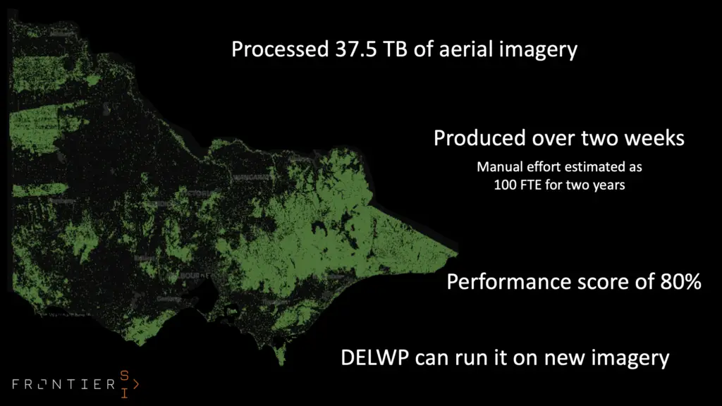
Instead of taking 100 staff two years to process the data, they managed to process 37.5 terabytes of data in just two weeks! They had a performance score of 80% so there is always room for improvement but we think that is very impressive.
STEMinar - AI and Geospatial Tech for Tree Detection
Want to learn more about how Caitlin and her team completed the task? Watch the following video to view our STEMinar with Dr Caitlin Adams. If you’re interested in viewing the data, check it out on Victoria’s Digital Twin.
About She Maps.
She Maps is Australia’s leading expert in drone and geospatial education.
She Maps assist schools with the purchasing of drones, school-industry created drone and geospatial teaching resources and highly supportive teacher professional development.
FREE eBook – How to start a drone program at your school – Teachers Guide – Download Now
Learning Solutions Guide – Programs, Products and Pricing Guide – Read now
Ready to buy drones for your school? Browse our convenient classroom kits!
You’re in Safe Hands!
She Maps is a CASA approved commercial operator to fly microdrones indoors with students and teachers. CASA holds commercial operators, to a higher standard than recreational users and educators. This means that She Maps has been assessed by CASA as having rigorous training and risk mitigation procedures in place.
Want some help?
Schedule a call with one of our team members to get some personalised recommendations.
Take our resources for a spin and join the thousands of teachers who love our ready-to-teach classroom materials. Try one of our complete units of work for free.