


Drones are one of the fastest growing technologies in the world and schools are looking at how they can incorporate them into their classrooms and clubs.
She Maps recently had the privilege of running a Q&A session with Melbourne Archdiocese Catholic Schools (MACS). We asked schools to think of all the unanswered questions they had about drones in the classroom.
The panel consisted of:
Below is the recording of the Q&A session, and we’ve extrapolated the questions and added more context below. Each question has been time-stamped in the video so that it can be easily viewed
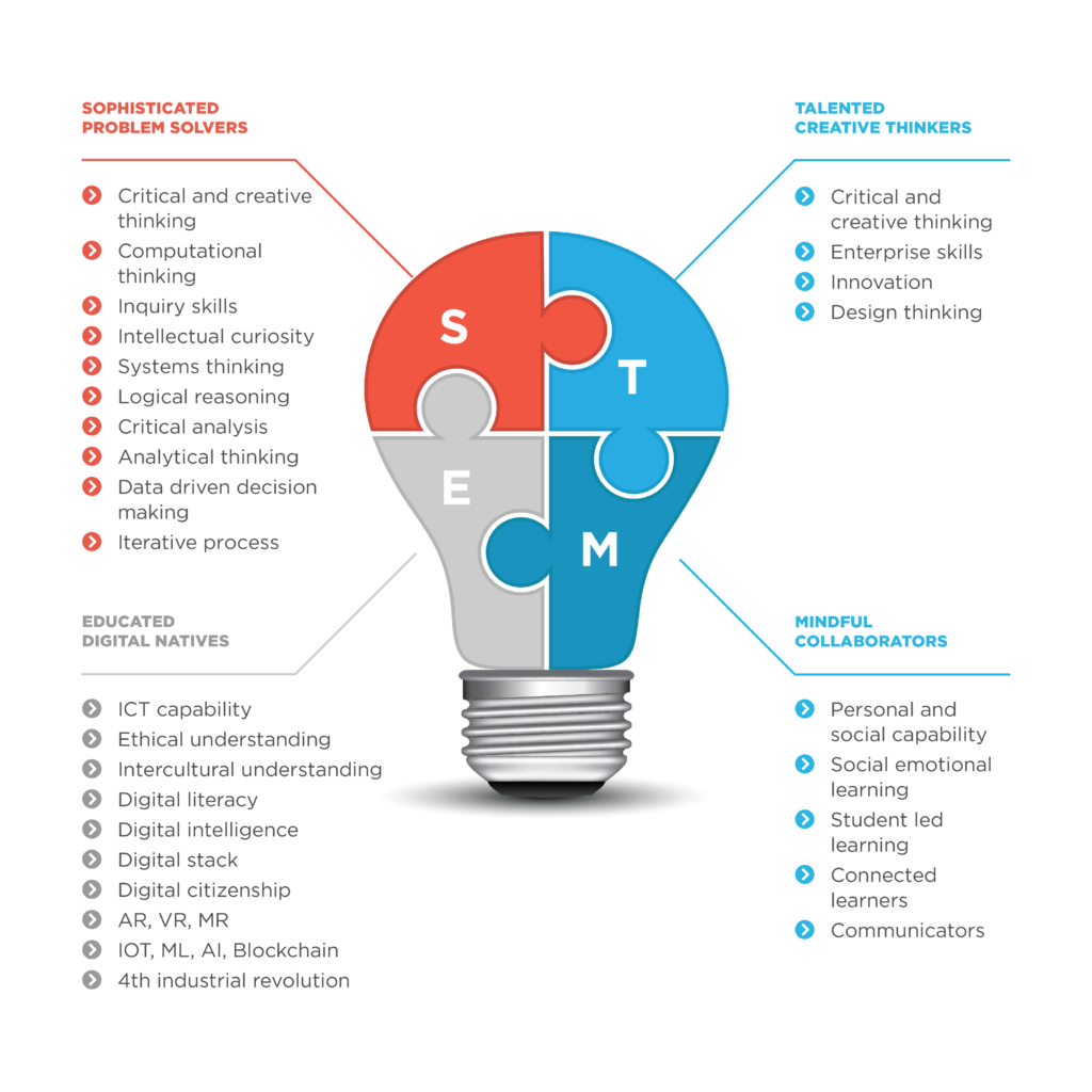
It is STEM by stealth, students are engaged and they are exploring different aspects of the STEM curriculum with a technology that is operating across so many industries. They are interdisciplinary. She Maps creates resources that not only cover Digital Technologies but also Geography, Science, Maths and of course Design Technologies.
Drones help to encourage the development of 21st-century skills. Students become Sophisticated problem solvers, Talented creative thinkers, Educated digital natives and Mindful Collaborators (STEM). This is what our Classroom Drone Essentials program provides for students, but also a PD for teachers so they gain confidence to organise and run their own programs.
STEM is more than Science, Technology, Engineering and Math
She Maps always starts with curriculum!
The obvious learning area is digital technologies and drones are a different option for understanding visual (block coding) and general-purpose programming (script coding, ie Python and Java). But you can use drones in other learning areas too.
For example, using as a topic in Geography – especially for inquiry learning. A She Maps unit of work – Drones to the Rescue looks at Landforms and Landscapes and Water in the World for Years 7 and 8 in the Australian Curriculum.
Science allows your students to look at the physics of drones, momentum, thrust and how a drone stays in the air. An example is testing how long a hovering drone would take to fall from different heights, we advise you not to test this with your drone, but to use the free-fall formula or an online calculator. The inquiry process in science can also be applied to this activity.
Drones can take a concept like 3D coordinate planes off the page and create a motivating and interesting set of lessons to explore this concept. It also means that students can develop more mature drone skills.
Studying drones as 3-dimensional figures also creates mathematical inquiry that explores geometric figures and how they influence design.
Other learning areas such as English can use drone photography to inspire creative writing and Media arts can use drones to help explore and learn about exploring camera angles.
There are many different drones out there, but we have done the research for you and believe that we have a drone that meets the needs of the classroom teacher.
Tello EDU – These are appropriate for Years 5-8 students as part of an indoor program. Take a look at Can I Fly My Drone Indoors? They are stable and easy for students to control. The Tellos have sensors that pick up patterns on the floor and allow the drone to stabilise itself. If they can’t pick up the patterns on the floor, they will drift. Take a look at inventive troubleshooting of low-light rooms with dark carpets!
It does have a forward-facing camera that allows the drone to capture both video and still images. She Maps even uses this camera for aerial surveys. Although we had to find a 3D printed attachment to help create the downward-facing camera that allows you to select the visual data.
We recommend that if you are starting a drone program in your high school, you introduce all students to microdrones first so they have confidence and understanding when they start to fly bigger drones.
Tello EDUs are microdrones, but they pack a lot of capability. Not only can you block code these drones, but they are also able to understand general-purpose programming such as Python and Java.
There are 2 apps that we recommend. At the base level, we have the Tello EDU app.

The Tello EDU app is a FREE building block system that allows you to move the drone autonomously with visual programming. It starts with basic movements but allows students to develop more advanced skills using loop functions as well as coordinate plane and curve blocks. It has a simple simulator for testing code and beginner pilots can be using this within a matter of minutes.
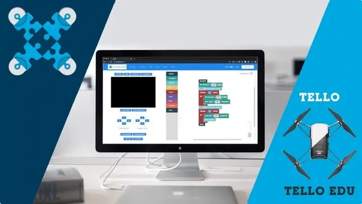
Droneblocks provides teachers and students with the ability to learn Blockly, Python, Open-CV, Node.js, and JavaScript by coding autonomous missions in the classroom using the Tello drone. The DroneBlocks app is a drag-and-drop system. This leads to DroneBlocks Code where students can take the next step with general-purpose coding.
The simulators that are available allow the pilot to test code before they apply to the real drone. You would never fly new code without testing it first, that is asking for a drone fail!
The Civil Aviation and Safety Authority (CASA) has certified the She Maps program, and we have created the risk analysis that goes along with it and the drone policy. We have created a system that minimises the risk to students, teachers and drones. When a She Maps professional development is presented to a school there are specific ways of running these sessions, some of the sections that are included are:
Here are a few suggestions for how to get involved with drones on a budget.
Classroom Drone Essentials – Online Together is our online professional learning community for teachers. Through 3 X zoom sessions teachers learn about how to set up their drones, what the rules and regulations are for flying microdrones indoors, all CASA approved, classroom management, resource selection, identifying the right program for your school and creating confidence in teachers using drones in their classroom.
Our She Maps Membership that comes as part of your Online Together PD is the online learning platform that provides teachers with units of work, case studies, posters, video demonstrations, presentations on the world of drones and Geographic Information Systems (GIS). This includes:
Take a look at the following blog Remote Pilot License (RePL) – Do I need this certification to fly drones to help you understand whether you need to get your RePL or not.
The short answer is no, you do not need a RePL if you are teaching students to fly drones in a school setting.
Geospatial refers to data that has a geographic or locational component. This type of data is collected by Geospatial technology such as:
Students can access and use data from a range of sources:
Pippa and Dronie is a beautifully illustrated book recommended for readers from Foundation to Year 4, celebrating diversity in STEM.
The book introduces children to real-life female role models doing amazing things in their work with drones.
With strong links to the Australian Curriculum and a variety of activities linked to STEM it is a great resource with a coding app as well!
Join in the adventure as Pippa and Dronie travel around Australia, finding out just how useful a drone can be!
If you are interested in finding out more about drone programs in schools, get in contact with our team.
She Maps is Australia’s leading expert in drone and geospatial education.
She Maps assist schools with the purchasing of drones, school-industry created drone and geospatial teaching resources and highly supportive teacher professional development.

Subscribe by email and never miss a blog post or announcement.
Take our resources for a spin and join the thousands of teachers who love our ready-to-teach classroom materials. Try one of our complete units of work for free.


